Trail Walking São Teotónio - Boucle de Cabo Sardao - Photo

Boucle de Cabo Sardao

 rigol05
rigol05

User

© OpenStreetMap contributors
Length
Length
1.6 km
Max alt
Max alt
49 m
Uphill gradient
Uphill gradient
31 m
Km-Effort
Km-Effort  
2 km
Min alt
Min alt
14 m
Downhill gradient
Downhill gradient
30 m
Boucle
Boucle
Yes
Creation date :
2018-06-26 15:09:31.993
Updated on :
2018-06-26 15:09:31.993

(0 Reviews)

Walking
Walking
27m
Difficulty : Unknown

Scan this QR Code to open this trail in the SityTrail application

FREE GPS app for hiking

Logo SityTrail SityTrail

IGN / Geographical institutes

Download SityTrail from the App Store Download SityTrail from Google Play

Logo SityTrail SityTrail World

The world is yours!

Download SityTrail from the App Store Download SityTrail from Google Play Download SityTrail on Huawei AppGallery

About

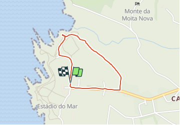
Trail Walking of 1.6 km to be discovered at Alentejo Region, Beja, São Teotónio. This trail is proposed by rigol05.

Description

A ajouter 23/05 Mauvais stationnement, déplacement du fourgon au village de Cavaleiro

Elevation profile

Positioning

Country:
Portugal
Region :
Alentejo Region
Department/Province :
Beja
Municipality :
São Teotónio
Location:
São Teotónio
Start:(UTM)
516288 ; 4161331 (29S) N.

Trails nearby

Trail Walking São Teotónio - Cabo Sardao - Photo
Walking
rigol05

Walking

Very easy
São Teotónio, Alentejo Region, Beja, Portugal
8.6 km | 11.5 km-effort
2h 40min
Yes
Trail Walking São Teotónio - Cavaleiro - Photo
Walking
rigol05

Walking

Very easy
São Teotónio, Alentejo Region, Beja, Portugal
12.3 km | 15.4 km-effort
3h 26min
Yes
Trail Walking São Teotónio - Cabo sarcoa à zabureija - Photo
Walking
sami55

Walking

Easy
São Teotónio, Alentejo Region, Beja, Portugal
11.8 km | 14 km-effort
4h 38min
No


Close
My subscriptions